
Safety & Mobility in the Downtown Core Project
 GALENA COOPER LIVING LAB:
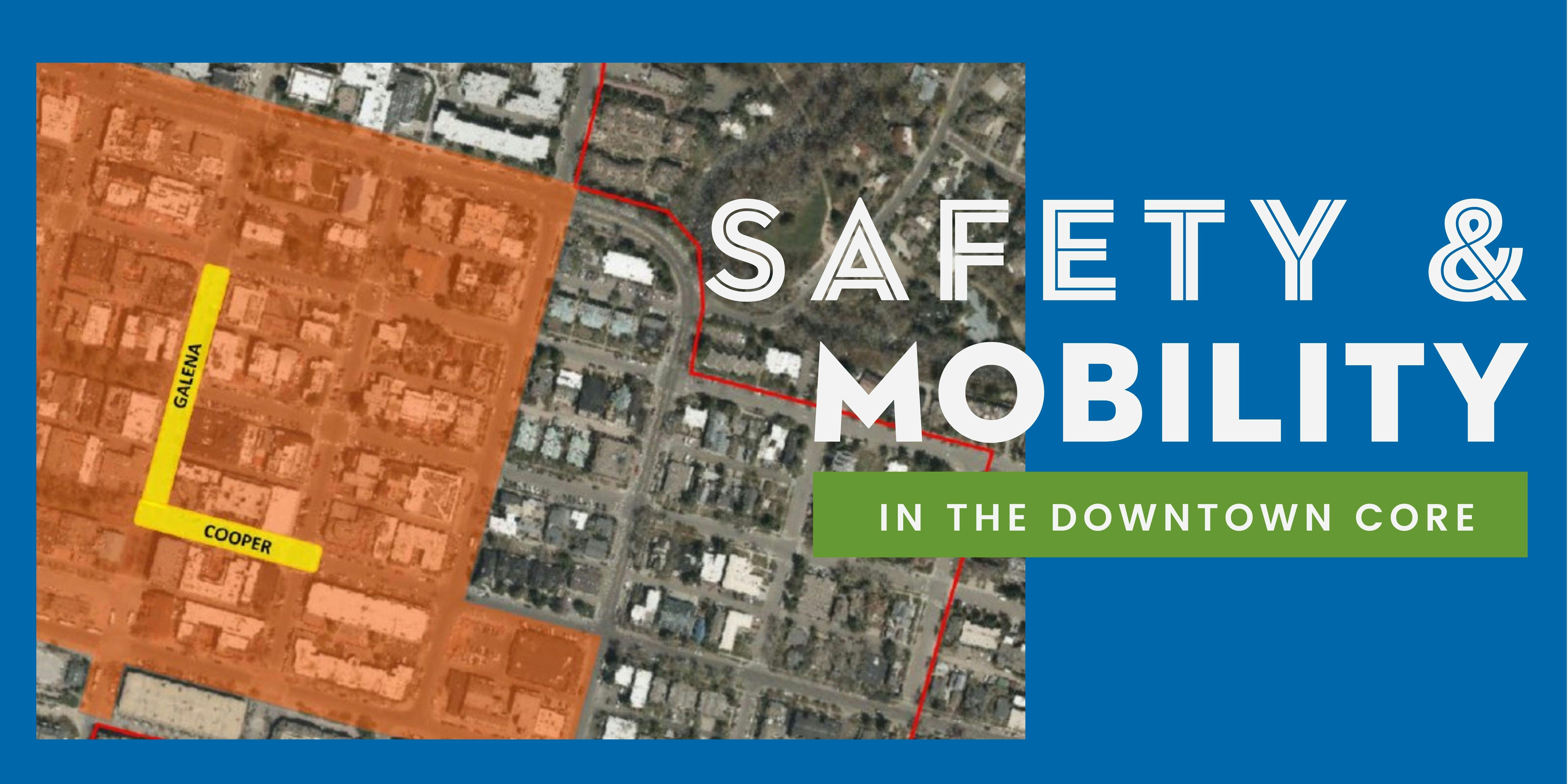
The City of Aspen is taking a big step this summer towards increasing Safety and Mobility in the Downtown Core for pedestrians, cyclists, and motorists. A Living Lab installed on South Galena Street from Main Street to Cooper Avenue and Cooper Avenue to Hunter Street, will allow the City to temporarily test the project and make modifications prior to any permanent safety and design improvements. This lab will be in place through September 2022.
Learn more at aspen.gov/LivingLab.
Experience it! If you have biked, walked or driven through the Galena Cooper Living Lab we wantContinue reading
GALENA COOPER LIVING LAB:
The City of Aspen is taking a big step this summer towards increasing Safety and Mobility in the Downtown Core for pedestrians, cyclists, and motorists. A Living Lab installed on South Galena Street from Main Street to Cooper Avenue and Cooper Avenue to Hunter Street, will allow the City to temporarily test the project and make modifications prior to any permanent safety and design improvements. This lab will be in place through September 2022.
Learn more at aspen.gov/LivingLab.
Experience it! If you have biked, walked or driven through the Galena Cooper Living Lab we want to hear about your experience. Please share your feedback.
Email: GalenaCooperLivingLab@aspen.gov
Call the hotline: 970-340-4334
PROJECT UPDATE:
Staff will provide an update on the Safety and Mobility in the Downtown Core project, including discussion on proposal for the living lab, at the February 15 City Council Work Session. You can attend the meeting in City Council Chambers or watch online by clicking the "View Event" link here.
PROJECT INFORMATION:
The “Safety and Mobility in the Core” project is a vision for a safe, connected, and active downtown core in Aspen.
For over a year, the City of Aspen has been exploring how right-of-way (ROW) space could be allocated differently to increase safety for all pedestrians, cyclists, and drivers. Whatever your mode of transportation, predictable behavior and communication with your fellow travelers are among the best ways to enhance safety; how space is used can reduce the risk of an unexpected situation and support safer traveling behaviors.
Staff also has looked at how the ROW space use could improve mobility and connectivity, invite vitality into the public ROW, and prioritize transit and/or shared mobility options in the Downtown Core.
The project team has followed up on Council direction and incorporated feedback from various public engagement opportunities such as questionnaires and focus groups as they refined concepts regarding a Living Lab in the core for Summer 2022. This proposal includes a range of options from a plan to test on Galena and Cooper to parking and transit programming enhancements to help mitigate any potential negative impacts.
As the city refines the living lab proposal, community members input on all these elements are needed. Please take the survey below or leave us an idea, comment, or question so all voices can be heard and input collected for consideration.
Currently, the team is preparing to bring the project back to Council in February and invites you to get reacquainted with the project, review work progress to date, and share your input and ideas on a proposed preferred option for implementation this summer.
PARKING CONSIDERATION:
Part of prioritizing space is looking at how to allocate it for pedestrians, cyclists, and vehicles, options which also involve discussions on parking such as spaces along Galena and Cooper. The current proposed plan available for feedback now does not propose removing parking spaces from the core, although distribution may look different. The proposed living lab maintains parking spaces, so someone can drive into the core and find parking if they choose that mode of transportation. It also proposes addressing direct impact of parking in areas through mitigation and programming options. For example, the city is exploring reclassifying spaces in the commercial core area or adjacent to the boundary from residential to core parking spaces. This approach could generate 47 core parking spaces by reclassifying these areas for a net gain of three spaces in the core area. Programming approaches could include options like enhancements to the valet parking program, progressive timing based on locations (e.g., reducing the time allowed to park in one spot based on turnover demand needs), progressive fees (higher fees in higher use areas), limiting construction parking, adding pick-up/drop-off spaces.
For reference, the city observes a consistent 85% occupancy level on parking in the core. This figure is calculated by comparing the number of spots used through payment tracking with the number of total spots available. What that means is that usually, there are 15% of the parking spaces in the core available for someone to park in. This may not be right in front of the business someone is headed to, but parking in the core can be found.
HOW TO PARTICIPATE:
- Subscribe to receive project updates
- Take the 2022 Winter Questionnaire
- Volunteer to participate in a small focus group
- Share your questions and comments below through the "Question and Comments" tab
- Email Project Manager, PJ Murray, Civil Engineer at pj.murray@cityofaspen.com
Questions & Comments
Please share your comments or questions about safety in the Downtown Core.
-
Share I know this isn't the Core, but...Why won't the City and County return the speed limit to 25 mph going east out of town past City Market? It changes to 35 mph at Cleveland Street, well within city limits. This is a high density area, with pedestrians and bicycles trying to cross the street or enter traffic. Nowhere else in town is 35 mph allowed. on Facebook Share I know this isn't the Core, but...Why won't the City and County return the speed limit to 25 mph going east out of town past City Market? It changes to 35 mph at Cleveland Street, well within city limits. This is a high density area, with pedestrians and bicycles trying to cross the street or enter traffic. Nowhere else in town is 35 mph allowed. on X (formerly Twitter) Share I know this isn't the Core, but...Why won't the City and County return the speed limit to 25 mph going east out of town past City Market? It changes to 35 mph at Cleveland Street, well within city limits. This is a high density area, with pedestrians and bicycles trying to cross the street or enter traffic. Nowhere else in town is 35 mph allowed. on Linkedin Email I know this isn't the Core, but...Why won't the City and County return the speed limit to 25 mph going east out of town past City Market? It changes to 35 mph at Cleveland Street, well within city limits. This is a high density area, with pedestrians and bicycles trying to cross the street or enter traffic. Nowhere else in town is 35 mph allowed. link
I know this isn't the Core, but...Why won't the City and County return the speed limit to 25 mph going east out of town past City Market? It changes to 35 mph at Cleveland Street, well within city limits. This is a high density area, with pedestrians and bicycles trying to cross the street or enter traffic. Nowhere else in town is 35 mph allowed.
AJK asked almost 5 years agoSpeed limit signs do not influence driver speeds rather roadway geometry, vehicle type and driver characteristics. Speed limit signs are based on speed studies that take these factors into consideration. Based on the Speed Studies done for this stretch of highway CDOT has determined that the speed limit needs to be 35 mph. In order to lower the speeds on this roadway, the roadway geometry would need to change.
-
Share Why does this project limit it's scope to the core? Cyclists and walkers need to get to the core from other areas of Aspen. In particular, the pedestrian through-way on Hopkins is extremely dangerous and burdensome for cyclists with the intersection of Hopkins with S Aspen, S Garmisch, and S 1st street. If Aspen wants to consider itself a bike-friendly town, it has a long way to go. on Facebook Share Why does this project limit it's scope to the core? Cyclists and walkers need to get to the core from other areas of Aspen. In particular, the pedestrian through-way on Hopkins is extremely dangerous and burdensome for cyclists with the intersection of Hopkins with S Aspen, S Garmisch, and S 1st street. If Aspen wants to consider itself a bike-friendly town, it has a long way to go. on X (formerly Twitter) Share Why does this project limit it's scope to the core? Cyclists and walkers need to get to the core from other areas of Aspen. In particular, the pedestrian through-way on Hopkins is extremely dangerous and burdensome for cyclists with the intersection of Hopkins with S Aspen, S Garmisch, and S 1st street. If Aspen wants to consider itself a bike-friendly town, it has a long way to go. on Linkedin Email Why does this project limit it's scope to the core? Cyclists and walkers need to get to the core from other areas of Aspen. In particular, the pedestrian through-way on Hopkins is extremely dangerous and burdensome for cyclists with the intersection of Hopkins with S Aspen, S Garmisch, and S 1st street. If Aspen wants to consider itself a bike-friendly town, it has a long way to go. link
Why does this project limit it's scope to the core? Cyclists and walkers need to get to the core from other areas of Aspen. In particular, the pedestrian through-way on Hopkins is extremely dangerous and burdensome for cyclists with the intersection of Hopkins with S Aspen, S Garmisch, and S 1st street. If Aspen wants to consider itself a bike-friendly town, it has a long way to go.
vicmaj asked almost 5 years agoThe core has been identified by the Pedestrian and Bicycle Master Plan as a barrier for connectivity for pedestrians and cyclists. In order to address the connectivity barrier, safe dedicated space for all users needs to be provided. The City works to improve bicycle and pedestrian infrastructure throughout town, the core is the focus of this project, and will include improvements to some key intersections. We are working on other connectivity projects in town that focus on providing safe routing into the core such as the Lake Ave pedestrian bikeway and a project in the Park and Midland Ave neighborhoods. Pedestrian and bicycle improvement projects occur incrementally by working with and gaining support from the community and Council.
-
Share How long will restaurants and other downtown businesses be allowed to use public right-of-ways for their private purposes? I was under the impression that expansion into public space was for a limited time, but have not seen plans to end this incursion. In addition to fairness issues (some get these spaces, others don't) some 'temporary' structures block sight-lines and create traffic safety problems. Can you tell the public when these eyesores will be eliminated? on Facebook Share How long will restaurants and other downtown businesses be allowed to use public right-of-ways for their private purposes? I was under the impression that expansion into public space was for a limited time, but have not seen plans to end this incursion. In addition to fairness issues (some get these spaces, others don't) some 'temporary' structures block sight-lines and create traffic safety problems. Can you tell the public when these eyesores will be eliminated? on X (formerly Twitter) Share How long will restaurants and other downtown businesses be allowed to use public right-of-ways for their private purposes? I was under the impression that expansion into public space was for a limited time, but have not seen plans to end this incursion. In addition to fairness issues (some get these spaces, others don't) some 'temporary' structures block sight-lines and create traffic safety problems. Can you tell the public when these eyesores will be eliminated? on Linkedin Email How long will restaurants and other downtown businesses be allowed to use public right-of-ways for their private purposes? I was under the impression that expansion into public space was for a limited time, but have not seen plans to end this incursion. In addition to fairness issues (some get these spaces, others don't) some 'temporary' structures block sight-lines and create traffic safety problems. Can you tell the public when these eyesores will be eliminated? link
How long will restaurants and other downtown businesses be allowed to use public right-of-ways for their private purposes? I was under the impression that expansion into public space was for a limited time, but have not seen plans to end this incursion. In addition to fairness issues (some get these spaces, others don't) some 'temporary' structures block sight-lines and create traffic safety problems. Can you tell the public when these eyesores will be eliminated?
Tom Gorman asked almost 5 years agoThe last day for permitted street activation is currently October, 31, 2021. The presentation on August 23 is to review the option to improve the safety for pedestrians, cyclists, and vehicles; it will not focus on activation within the ROW. Staff is proceeding with Council for direction at a work session scheduled in September to discuss the future for any activation.
Follow Project
Documents
-
 02.11.2022 Memo to Council for February 15 Work Session (4.47 MB) (pdf)
-
02.11.2022 | Phase 3 Engagement Final Report (2.36 MB) (pdf)
-
12.01.2021 | ACRA Membership Meeting Presentation (2.28 MB) (pdf)
-
11.08.2021 | Informational Memo to Council (1.38 MB) (pdf)
-
08.23.2021 | Informational Memo to Council (2.68 MB) (pdf)
-
07.14.2021 | Informational Memo to Council (1.55 MB) (pdf)
-
06.18.2021 | Memo to Council for June 21 Work Session (1.48 MB) (pdf)
-
01.29.2021 Memo to Council for February 1 Work Session (1.64 MB) (pdf)

Who's Listening
-
Phone 970-920-5056 Email pj.murray@cityofaspen.com -
Phone 970-920-5293 Email denise.white@cityofaspen.com